Qualitative and quantitative interpretations of high-resolution aeromagnetic data of Saki-East area, for basement and structural framework

Authors

  • E. O. Adeniyi Department of Pure and Applied Physics, Ladoke Akintola University of Technology, Ogbomoso, Nigeria
  • L. A. Sunmonu Department of Pure and Applied Physics, Ladoke Akintola University of Technology, Ogbomoso, Nigeria
  • O. P. Oladejo Department of Physical Sciences Education, Emmanuel Alayande University of Education, P.M.B 1010 Oyo, Oyo State, Southwestern Nigeria
  • C. O. Ogunkoya Department of Physics, Ajayi Crowther University, P.M.B 1066, Oyo Town, Oyo State, Southwestern Nigeria
  • O. M. Adedokun Department of Pure and Applied Physics, Ladoke Akintola University of Technology, Ogbomoso, Nigeria
  • K. N. Alao Department of Pure and Applied Physics, Ladoke Akintola University of Technology, Ogbomoso, Nigeria

Keywords:

Earth tremor, Euler deconvolution, Aeromagnetic, Source parameter imaging

Abstract

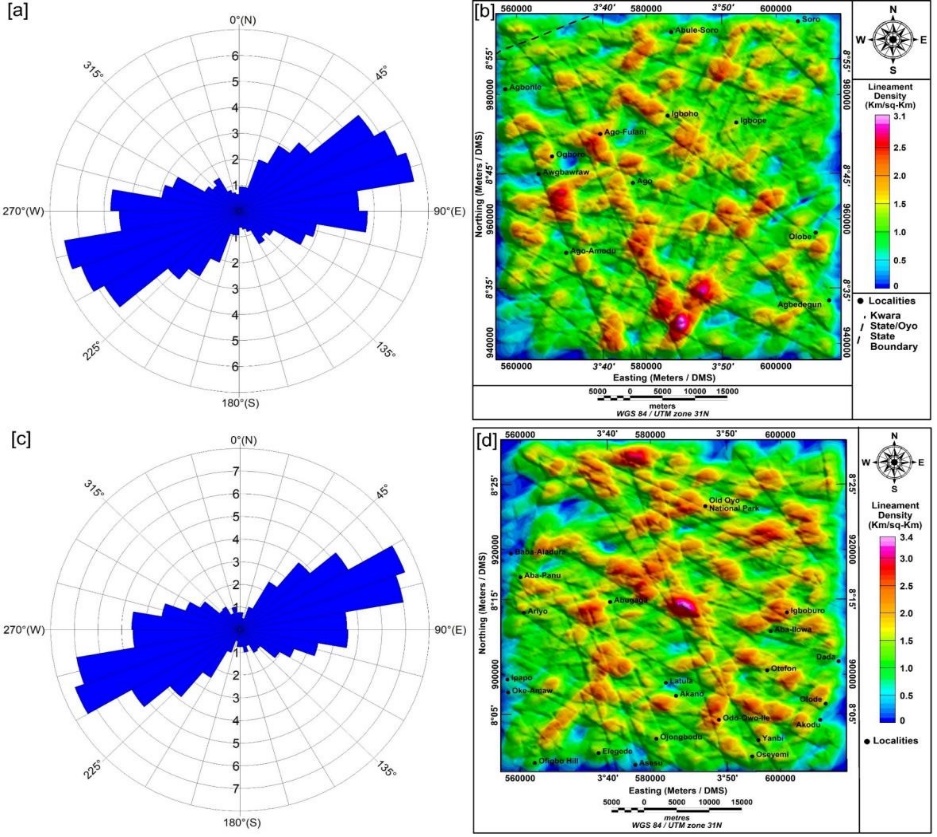
Earth tremor is a small earthquake or seismic event that occurs in seismically unstable region. However there have been little information about the earth tremor before year 1987, but events between 1990 and 2000 have triggered further researches. This research work is aimed at qualitatively and quantitatively interpret high resolution aeromagnetic data of Saki-East area to provide basement and structural framework of the study area. The aeromagnetic data of the study area consisting of Igboho data sheet 200 and Lechilaku sheet 221 were processed using Oasis Montaj software and interpreted for mapping basement and structural stability in the area. Enhancement process was further carried out on the data to generate residual aeromagnetic data used in determining the lineament orientations in the study area. 3D Euler deconvolution and Source Parameter Imaging (SPI) techniques were implored to determine basement depth of subsurface geological structures. The result shows positive correlation with geologic structures, low magnetic anomalies revealed subsurface deformation of crystalline basement rocks. 3D Euler solutions for SI = 1 shows large clusters depicting geological bodies associating with faults. The magnetic basement depth from 3D Euler and SPI shows over 90% dominance of shallow depth range of 3-600 m in the study area, this revealed that the dominant shallow depth of magnetic basement causes the faulting system of the study area becoming weak zones through which tremor occurs. The lineaments in the study areas are classified into major and minor lineaments, the major lineaments are prominent within the basement rocks and are possibly produced by the regional historic orogenic movement that affected Nigeria basement.
Dimensions

G. Gibson & M. Sandiford, “Seismicity and induced earthquakes”, Office of the New South Wales Chief Scientist and Engineer University of Melbourne, 2013. [Online]. https://www.chiefscientist.nsw.gov.au/ data/assets/pdf file/0017/31616/Seismicity-and-induced-earthquakesGibson-and-Sandiford.pdf. .

A. U. Sylvester & K. M. Onuoha, “An analysis of earthquake focal depths in Africa (1900-2000)”, The IUP Journal of Earth Sciences 4 (2010) 42. https://ssrn.com/abstract=1584559.

M. A. Al-Badani & Y. M. Al-Wathaf, “Using the aeromagnetic data for mapping the basement depth and contact locations, at Southern Part of Tihamah Region, Western Yemen”, Egyptian Journal of Petroleum 27 (2018) 485. https://doi.org/10.1016/j.ejpe.2017.07.015.

N. G. Goki, S. A. Onwuka, A. B. Oleka, S. Iyakwari, I. Y. Tanko, A. A. Kana, A. A., Umbugadu, and H. O. Usman, “Preliminary geological evidence for multiple tremors in Kwoi, Central Nigeria”, Geo-environmental Disasters 7 (2020) 22. https://doi.org/10.1186/s40677-020-00156-w.

D. E. Ajakaiye, M. A. Daniyan, S. B. Ojo & K. M. Onuoha, “The July 28, 1984 southwestern Nigeria earthquake and its implications for the understanding of the tectonic structure of Nigeria”, Journal of Geodynamics 7 (1987) 205. https://api.semanticscholar.org/CorpusID:128895095.

O. P. Oladejo, T. A. Adagunodo, I. A. Sunmonu, M. A. Adabanija, N. K. Olasunkanmi & N. Omeje, “Structural analysis of subsurface stability using aeromagnetic data: a case of Ibadan, southwestern Nigeria”, Journal of Physics Conference Series 1299 (2019) 012083. https://iopscience.iop.org/article/10.1088/1742-6596/1299/1/012083.

O. U. Akpan, M. A. Isogun, T. A. Yakubu, A. A. Adepelumi, C. S. Okereke, A. S. Oniku & M. I. Oden, “An evaluation of the 11th September, 2009 Earthquake and its implication for understanding the seismotectonics of South Western Nigeria”, Open Journal of Geology 4 (2014) 542. http://dx.doi.org/10.4236/ojg.2014.410040.

M. A. Isogun & A.A. Adepelumi, “The review of seismicity of central Mid-Atlantic Fracture zones”, International Journal of Scientific & Engineering Research 5 (2014) 1309. https://www.ijser.org/researchpaper/The-Review-of-Seismicity-of-Central-Mid-Atlantic-Fracture-Zones.pdf.

C. C. Okpoli & M. A. Oladunjoye, “Precambrian basement architechture and lineaments mapping of Ado-Ekiti region using aeromagnetic data”, Geosciences Research 2 (2017) 27. http://dx.doi.org/10.22606/gr.2017.21005.

N. G. Obaje, “Geology and Mineral Resources of Nigeria”, in Lecture Notes in Earth Sciences, Springer-Verlag, Berlin, Heidelberg, 2009, pp. 23. https://doi.org/10.1007/978-3-540-92685-6.

O. T. Olurin, “Interpretation of high resolution airborne magnetic data (HRAMD) of Ilesha and its environs, Southwest Nigeria, using Euler deconvolution method”, Original scientific paper 64 (2017) 227. https://doi.org/10.1515/rmzmag-2017-0013.

O. P. Oladejo & C. O. Ogunkoya, “Evaluation of upward continuation and reduction to magnetic equator on airborne magnetic data”, FUDMA Journal of Sciences (FJS) 7 (2023) 192. https://doi.org/10.33003/fjs-2023-0705-1968.

I. A. Akinlabi, O. P. Oladejo & C. O. Ogunkoya, “Investigation of magnetic anomalies and depth to magnetic sources over igboho area using high resolution aeromagnetic data”, Nigeria Journal of Physics 32 (2023) 70. https://njp.nipngr.org/index.php/njp/article/view/121.

NGSA (Nigeria Geological Survey Agency) Geological map Records by Nigeria Geological Survey Agency, Nigeria, 2011. https://ngsa.gov.ng/.

A. O. Aina, “Reduction to equator, reduction to pole and orthogonal reduction of magnetic profiles”, Exploration Geophysics 17 (1986) 141.https://doi.org/10.1071/EG986141.

L. Leu, “Magnetic exploration with reduction of magnetic data to the equator” U.S. Patent and Trademark Office, 1986. Patent No. 4,570,122. [Online]. https://patents.google.com/patent/US4570122A/en?inventor=Lei-Kuang+Leu.

T. O. Oyeniyi, T. I. Akanbi & A. H. Falade, “An application of soft sign function (sf) filter to low-latitude aeromagnetic data of Tafawa-Balewa area, Northern Nigeria for geostructural mapping and tectonic analysis”, Results in Geophysical Sciences 14 (2023) 1. https://doi.org/10.1016/j.ringps.2023.100063.

G. O. Layade, V. Makinde, A. L. Bisilimi & C. O. Ogunkoya, “Determination of magnetic source depth using local wave number (lwn) and horizontal gradient magnitude (HGM) methods for high resolution aeromagnetic data of Igbeti”, Nigerian Journal of Physics 28 (2019) 109. https://njp.nipngr.org/index.php/njp/article/view/121.

D. E. Ajakaiye, D. H. Hall, T. W. Millar, P. J. Verheijen, M. B. Awad, & S. B. Ojo, “Aeromagnetic Anomalies and Tectonic Trends in and around the Benue Trough, Nigeria”, Nature 319 (1986) 582. https://doi.org/10.1038/319582a0.

P. I. Olasehinde, P. C. Pal & A. E. Annor, “Aeromagnetic anomalies and structural lineaments in the Nigerian basement complex”, Journal of African Earth Sciences 11 (1990) 351. https://doi.org/10.1016/0899-5362(90)90014-6.

D. T. Thompson, “A new technique for making computer-assisted depth estimates from magnetic data”, Geophysics 47 (1982) 31. https://doi.org/10.1190/1.1441278.

A. B. Reid, J. M. Allsop, H. Granser, A. J. Millett & I. W. Somerton, “Magnetic Interpretation in Three Dimensions Using Euler Deconvolution”, Geophysics 55 (1990) 80. https://doi.org/10.1190/1.1442774.

A. Spector & F. S. Grant, “Statistical model for interpreting aeromagnetic data”, Geophysics 35 (1970) 293. https://doi.org/10.1190/1.1440092.

Published

2024-11-16

How to Cite

Qualitative and quantitative interpretations of high-resolution aeromagnetic data of Saki-East area, for basement and structural framework. (2024). African Scientific Reports, 3(3), 239. https://doi.org/10.46481/asr.2024.3.3.239

How to Cite

Qualitative and quantitative interpretations of high-resolution aeromagnetic data of Saki-East area, for basement and structural framework. (2024). African Scientific Reports, 3(3), 239. https://doi.org/10.46481/asr.2024.3.3.239