
Bathymetric survey and volumetric analysis of Bakolori dam reservoir North West Nigeria
Keywords:
Bathymetric Survey, Capacity Loss, Siltation VolumeAbstract
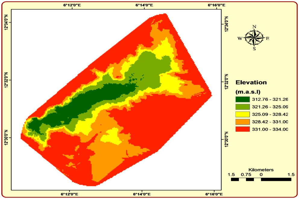
Many approaches have been devised for measuring water depth in bathymetric surveys, which are used to assess sediment deposited directly in lakes and reservoirs. This technique is mostly used to calculate the reservoir's capacity and the amount of sedimentation that occurs there. The results of the volumetric analysis and bathymetric survey of the Bakolori Dam reservoir, which is situated in Northwestern Nigeria, are presented in this work. During this investigation, the differential Global Positioning System receiver (GPS), automatic level measuring tool, echo-sounder, and engine boat were utilized. ArcGis 10.0 was used to analyze the acquired data. In order to evaluate the reservoir capacity loss during the Bakolori reservoir's operating period as of 1983, the designed computed reservoir capacity was compared with the current bathymetry survey. At a spillway crest elevation of 334 meters above mean sea level (amsl), the reservoir's initial capacity is reported as 430 million cubic meters (MCM). However, the capacity has since been revised to 291 meters at the same level, with a volume change of 139,269,495 m3. As a result, the reservoir's volume changed by approximately 139 MCM during a thirty-five (35) year period of service, representing a loss of storage capacity, while the annual siltation rate was around 3,979,128 m3/a. This indicated that 33% of the reservoir's storage capacity had silted up. This is demonstrated by the aquatic weeds that have grown to a height of 334.21 meters on the lake's surface, rising from the lakebed. Therefore, to prevent total siltation, the dam reservoir needs to be adequately dredged.
Published
How to Cite
Issue
Section
Copyright (c) 2024 Ahmed Mahi Shuaibu

This work is licensed under a Creative Commons Attribution 4.0 International License.
How to Cite
Similar Articles
- Omolara A. Adenuga, Olateju A. Bayewu, Hamid T. Oladunjoye, Sofiat A. Adekoya, Integrated geophysical assessment of a municipal waste disposal site for its geological suitability in terms of the underlain material , African Scientific Reports: Volume 2, Issue 3, December 2023
- E. Agboeze, N. P. Ani, E. O. Omeje, Extraction and Characterization of Pharmaceutical Grade Microcrystalline Cellulose From Bambara Nut (Voandzeia Subterranean (L) Thousars) Husk , African Scientific Reports: Volume 1, Issue 2, August 2022
- Qrisstuberg M. Amua, Emmanuel K. Ukpoko, Pesticides survey and identification of common insecticides used for foodstuff storage in Makurdi, Benue State, Nigeria , African Scientific Reports: Volume 4, Issue 1, April 2025
- Shadreck Muyambo, Jack A Urombo, Garry K. Masoha, Livingstone Jenya, A mathematical framework for assessing food fraud intentions , African Scientific Reports: Volume 4, Issue 3, December 2025
- Matthew Onyema Agu, Umar Kyakyaidi, Collins Chibuzor Odidika, Inya Inya Agha, Physical quality assessment of selected made in Nigeria synthetic surfactants for surface activity in Bali, Taraba State, Nigeria , African Scientific Reports: Volume 3, Issue 1, April 2024
- A. P. Onatunji, O. M. Ajao, K. T. Amzat, L. A. Oladimeji, O. A. Olalude, Bayesian analysis of the effects of some identified risk factors of systolic pressure among pregnant women in Ogbomoso, Oyo State , African Scientific Reports: Volume 3, Issue 2, August 2024
- Ignatius Nwoyibe Ogbaga, Henry Friday Nweke, Juliana Ngozi Ndunagu, Deploying persuasive technology-based model in the prevention and control of malaria in Nigeria to reduce incidence of deaths , African Scientific Reports: Volume 2, Issue 3, December 2023
- Christopher Ikechukwu Ekeocha, Ikenna Benedict Onyeachu, Ini-Ibehe Nabuk Etim, Emeka Emmanuel Oguzie, Review of forms of corrosion and mitigation techniques: A visual guide , African Scientific Reports: Volume 2, Issue 3, December 2023
- M. A. Aliu, A. M. Junaid, A. Ibraheem, A. Ishaq, A. Lawal, K. E. Ayeni, A. R. Lawal, L. B. Abdulrauf, Dispersive liquid-liquid microextraction/HPLC techniques for determination of oxytetracycline and doxycycline residues in beef samples: method developments and statistical analysis , African Scientific Reports: Volume 2, Issue 1, April 2023
- A. A. Yahaya, W. A. Yahya, I. A. Rahmon, Effect of hydrostatic pressure on opto-electronic, elastic and thermoelectric properties of the double perovskites Rb2SeX6(X=Cl,Br): a DFT study , African Scientific Reports: Volume 3, Issue 1, April 2024
You may also start an advanced similarity search for this article.

