Urban Flooding Vulnerability Analysis Using Weighted Linear Method With Geospatial Information System

Authors

  • E. S. Okonofua Department of Civil Engineering, Faculty of Engineering, University of Benin, Benin City, Nigeria
  • N. Kayode-Ojo Department of Civil Engineering, Faculty of Engineering, University of Benin, Benin City, Nigeria

Keywords:

Flood, Precipitation, Vulnerability, Soil texture, Land use

Abstract

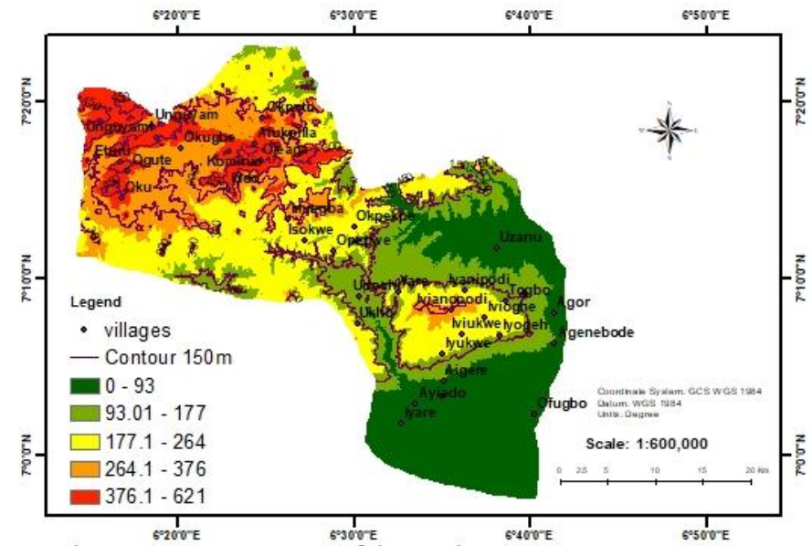
This study was carried out to investigate the causative factors responsible for flooding in Etsako east, Nigeria. The study applied weighted linear method and geospatial information technology to obtain relevant data which were subjected to analysis. Sentinel 2 imagery of the area was downloaded from the United States Geological Survey (USGS) website and analyzed to produced digital elevation model, rainfall distribution, soil texture classification, topographic wetness index (TWI), hillside slope, land use/cover contour and slope maps of the area. Saaty weighted scale (1 – 5) was used to assign importance to the factors selected. The results presented using relevant maps revealed that, TWI (14%), precipitation (14%), distance to river (12%), elevation (11%) and slope (10%) are the major factors responsible for flooding in the area. Using built up areas only (46.57 km2 ); 38.6% of it is within the risk range of High to very High flood vulnerability, moderate vulnerability zone (17.97 km2 ) occupied 27.28%. Low vulnerability zone occupied 22.05%,(10.27 km2 ) while no vulnerability zone occupied 12.05% (5.61 km2). Communities in the high flood vulnerable region includes Iddo, Iyukwe, Iyogeh, Imiegb and Opepwe; flood control measures and early warning systems should be developed to mitigate the impact of flooding in the area.

Dimensions

F. Mukherjee & D. Singh, “Detecting flood prone areas in Harris County: A GIS based analysis”, GeoJournal 85 (2019) 647. https://doi.org/10.1007/s10708-019-09984-2

C. Cao, M. Xu & P. Insom, Environmental remote sensing in flooding areas, Higher Education Press and Springer Nature, Singapore, 2012. https://doi.org/10.1007/978-981-15-8202-8

I. Elkhrachy, “Flash flood hazard mapping using satellite images and GIS tools: A case study of Najran City, Kingdom of Saudi Arabia (KSA)”, The Egyptian Journal of Remote Sensing and Space Science 18 (2015) 261. https://doi.org/10.1016/j.ejrs.2015.06.007

J. R. Adewumi, O. J. Ejeh, K. H. Lasisi & F. O. Ajibade, “A GIS-AHP based approach in sitting MSW landfills in a Nigerian confluence state”, Springer Nature Applied Sciences 1 (2019) 1528. https://doi.org/10.1007/s42452-019-1500-6

J. R. Adewumi, J. K. Akomolafe & F. O. Ajibade, “Development of flood prone area map for Igbokoda township using geospatial technique”, Journal of Applied Science and Process Engineering 4 (2017) 178. https://doi.org/10.33736/jaspe.433.2017

F. E. Abellavia, “Prototype land cover map over Africa at 20 m released”, Climate change initiative European space agency, (2018) 7. https://www. esa-landcover-cci.org/?q=node/187

E. O. Eguaroje, T. A. Alaga, J. O. Ogbole, I. S. Kolawole, K. H. Muibi, D. S. Popoola, S. A. Samson, J. E. Adewoyin, R. A. Badru & O. O. Ajileye, “Flood vulnerability assessment of Ibadan City, Oyo state, Nigeria”, World Environment 5 (2015) 159. https://doi.org/10.5923/j.env.20150504.03

V. Flemas, “Remote sensing of floods and flood-prone: An overview, Journal of Coastal research 31 (2015) 1013. https://doi.org/10.2112/JCOASTRES-D-14-00160.1

T. Giuseppe, C. F. O. Iyalomhe & P. O. Adekola, “Determinants of flooding and strategies for mitigation; two-year case study of Benin City”, Journal of geosciences, 21 (2019) 6. https://doi.org/10.3390/geosciences9030136

I. T. Ezekiel, N. Maurice & K. Maurice, “Seawater intrusion vulnerability assessment of a coastal aquifer: North coast of Mombasa, Kenya as a case study”, International Journal of Engineering Research and Applications 6 (2016) 45. https://www.ijera.com/papers/Vol6 issue8/Part-%203/G0608033745.pdf

B. Jabri & M. A. Hessane, “Production of a curve number map using GIS techniques in the watershed of the high Sebou (Morocco)”, E3S Web of Conferences 150 (2020) 03003. https://doi.org/10.1051/e3sconf/202015003003

S. A. Doocy, S. Daniels, S. Murray & T. D. Kirsch, “The human impact of floods: A historical review of events 1980–2009 and systematic literature review”, PLOS Currents 5 (2013) 17. https://doi.org/10.1371/currents.dis.f4deb457904936b07c09daa98ee8171a

H. Sharif, F. Al-Juaidi, A. Al-Othman, I. Al-Dousary, S. Jamal-Uddeen & A. Elhassan, “Flood hazards in an urbanizing watershed in Riyadh, Saudi Arabia”, Geomatics, Natural Hazards, and Risk 7 (2016) 720. https://doi.org/10.1080/19475705.2014.945101https://doi.org/10.1080/19475705.2014.945101

C. Kousky, “A historical examination of the corps of engineers and natural valley storage protection: The economics and politics of “green” flood control”, Journal of Natural Resources Policy Research 7 (2015) 40. https://doi.org/10.1080/19390459.2014.963372

C. Klemas, “The role of remote sensing in predicting and determining coastal storm impact”, Journal of Coastal Research 25 (209) 1264. https://www.jstor.org/stable/27752776

Z. Sen, Flood modeling, prediction and mitigation, Springer Cham, 2018. https://doi.org/10.1007/978-3-319-52356-9

A. Glaize, A. Duenas, C. Di Martinelly & I. Fagnot, (2019). “Healthcare decision-making applications using multicriteria decision analysis: A scoping review”, Journal of Multi-Criteria Decision Analysis 26 (2019) 83. https://doi.org/10.1002/mcda.1659

P. A. Bariweni, C. C. Tawari & J. F. N. Abowei, “Some environmental effects of flooding in the Niger Delta region of Nigeria”, International Journal of Fisheries and Aquatic Sciences 1 (2012) 35. http://www.maxwellsci.com/print/ijfas/v1-35-46.pdf

O. Agbonkhese, G. L. Yisa & P. I. Daudu, “Bad drainage and its effects on road pavement conditions in Nigeria”, Journal of Civil and Environmental Research 3 (2013) 11. https://www.iiste.org/Journals/index.php/CER/article/view/7717

I. J. Apekejiori, “Flood monitoring and flood risk Assessment in Agenebode, Edo State, Nigeria”, International Journal of Engineering Research and Application 7 (2017) 53. http://dx.doi.org/10.9790/9622-0703015359

P. Negi, & K. Jain, “Spatial multicriteria analysis for siting groundwater polluting industries”, Journal of Environmental Informatics 12 (2008) 63. https://doi.org/10.3808/jci.200800124

C. J. Van Westen, “Remote sensing and GIS for natural hazards assessment and disaster risk management”, In J. F. Schroder & M. P. Bishop (Eds.), Treatise on geomorphology 3 (2013) 298. https://www.cdema.org/virtuallibrary/images/Background%20paper%20Spatial%20data%20for%20hazard%20and%20risk%20assessment.pdf

A. D. Weiss, (2001). “Topographic position and landforms analysis”, The Nature Conservancy 12 (2001) 9. http://www.jennessent.com/downloads/TPIposter-TNC 18x22.pdf

H. Zabihi, M. Alizadeh, P. K Langat, M. Karami, H. Shahabi, A. Ahmad, M. N. Said & S. Lee, “GIS multi criteria analysis by ordered weighted averaging (OWA): Toward an integrated citrus management strategy”, Sustainability 11 (2019) 1009. https://doi.org/10.3390/su11041009

S. Park, C. Choi, B. Kim & J. Kim, “Landslide susceptibility mapping using frequency ratio, analytic hierarchy process, logistic regression, and artificial neural network methods at the Inje area, Korea”, Environmental Earth Sciences 68 (2013) 1464. https://doi.org/10.1007/s12665-012-1842-5

T. L. Saaty, The analytic hierarchy process: Planning, priority setting, resource allocation (decision making series), McGraw-Hill International Book Company, 1980. https://doi.org/10.1016/0377-2217(82)90022-4

F. O. Ajibade, O. Olajire & T. Ajibade, “Groundwater potential assessment as a preliminary step to solving water scarcity challenges in Ekpoma, Edo State, Nigeria”, Acta Geophysica 12 (2021) 723. https://doi.org/10.1007/s11600-021-00611-8

F. O. Ajibade, N. A. Nwogwu, B. Adelodun, T. S. Abdulkadire, T. F. Ajibade, K. H. Lasisi, O. G. Fadugba, T. A. Owolabi & O.O. Olajire, “Application of RUSLE integrated with GIS and remote sensing techniques to assess soil erosion in Anambra state, south-eastern, Nigeria”, Journal of Water and Climate Change 11 (2020) 422. https://doi.org/10.2166/wcc.2020.222

Q. Zou, J. Z. Zhou, C. Zhou, L. X. Song & J. Guo, “Comprehensive flood risk assessment based on set pair analysis-variable fuzzy sets model and fuzzy AHP” Stochastic Environmental Research and Risk Assessment 27 (2013) 546. https://doi.org/10.1007/s00477-012-0598-5

S. Vorogushyn, K. Lindenschmidt, H. Kreibich & H. Apel, “Analysis of a detention basin impact on dike failure probabilities and flood risk for a channel-dike-floodplain system along the river Elbe, Germany”, Journal of Hydrology 436 (2012) 131. https://doi.org/10.1016/j.jhydrol.2012.03.006

M. S. Tehrany, and L. Kumar, “The application of a Dempster–Shafer based evidential belief function in flood susceptibility mapping and comparison with frequency ratio and logistic regression methods”, Environmental Earth Sciences 77 (2018) 24. https://doi.org/10.1007/s12665-018-7667-0

A. O. Ogunlela & B. Adelodun, “Kinematic flood routing of Asa River, Ilorin, Nigeria”, International Journal of Engineering and Technical Research 2 (2014) 17. https://www.academia.edu/10381185/Kinematic_Parameters_for_Asa_River_Routing

J. O. Ehiorobo & O. C. Izinyon, Measurements and documentation for flood and erosion monitoring and control in the Niger Delta states of Nigeria, TS07EEngineering Surveying, FIG Working Week 2011 Bridging the Gap between Cultures, Marrakech, Morocco, 2012. https://www.fig.net/resources/proceedings/fig_proceedings/fig2011/papers/ts07e/ts07e_ehiorobo_izinyon 5126.pdf

K. Li, S. Wu, E. Dai, & Z. Xu, “Flood loss analysis and quantitative risk assessment in China natural hazards”, Journal of the International Society for the Prevention and Mitigation of Natural Hazards 63 (2012) 760. https://doi.org/10.1007/s11069-012-0180-y

A. A. Komolafe, B. S. Awe, I. E. Olorunfemi & P. G. Oguntunde, “Modelling flood-prone area and vulnerability using integration of multi-criteria analysis and HAND model in the Ogun River basin, Nigeria”, Hydrological Sciences Journal 65 (2020) 1783. https://doi.org/10.1080/02626667.2020.1764960

A. E. Adefisan, B. S. Abdulkareem & R. I. Orimoloye, “Application of geospatial technology in identifying areas vulnerable to flooding in Ibadan metropolis”, Journal of Environment and Earth Science 5 (2015) 166. https://www.academia.edu/22749676/Application_of_Geo_Spatial_Technology_in_Identifying_Areas_Vulnerable_to_Flooding_in_Ibadan_Metropolis

O. Ajayi, S. B. Agbola, B. F. Olokesusi, B. Wahab, O. J. Taiwo, M. A. Gbadegesin, D. O. Taiwo, O. Kolawole, A. B. Muili, M. Adeola, O. G. Olutade, F. Shi-ji, F. & N. Abiola, “Flood management in an urban setting: A case study of Ibadan metropolis”, Special Publication of the Nigerian Association of Hydrological Sciences (2012) 65. http://journal.unaab.edu.ng/index.php/NAHS/article/download/914/882

J. R. Adewumi, J. K. Akomolafe, F. O. Ajibade & B. B. Fabeku, “Application of GIS and remote sensing technique to change detection in land use/land cover mapping of Igbokoda, Ondo State, Nigeria”, Journal of Applied Science and Process Engineering 3 (2016) 54. http://dx.doi.org/10.33736/jaspe.173.2016

Published

2023-10-18

How to Cite

Urban Flooding Vulnerability Analysis Using Weighted Linear Method With Geospatial Information System. (2023). African Scientific Reports, 2(3), 104. https://doi.org/10.46481/asr.2023.2.3.104

Issue

Section

Original Research

How to Cite

Urban Flooding Vulnerability Analysis Using Weighted Linear Method With Geospatial Information System. (2023). African Scientific Reports, 2(3), 104. https://doi.org/10.46481/asr.2023.2.3.104